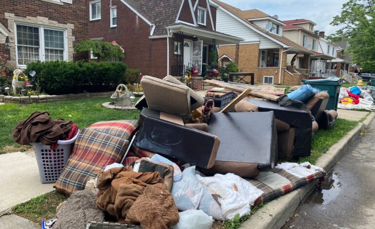
DEARBORN — The Dearborn Engineering Department answered the following questions regarding recent flooding in the city. The questions from The Arab American News were conveyed through the city’s public information director, Mary Laundroche.
A federally-mandated sewer separation project to mitigate pollution into the Rouge River was completed ahead of schedule this year. The city added a second sewer pipe parallel to the existing ones in order to have two separate pipes. This separated sewage water from the overflow into the Rouge River during heavy downpours. If there is a separate sewage line that transports sewage water from residents to the treatment facility, without having to mix with the rainwater during heavy rains, why did the sewage lines back up into basements during the recent storm?
Placing a separate sewer pipe for waste water locally for a few blocks does not completely separate the sewer system until the new sewer pipe is constructed all the way to the sewer outlet and separately connected to the main sanitary sewer line.
In east Dearborn, the only outlet to the Rouge River and sanitary main sewer are located on Prospect Avenue. Construction of a new large diameter sanitary sewer from Tireman Avenue to Prospect Avenue is required, with all waste water connections from all houses to be transferred to a new sanitary sewer.
In last four years, only 25 percent of the drainage area has been separated. The remaining 75 percent of the drainage area is still serviced by the combined sewers.
This concept would require tearing down all East-West streets between Chase Road and Miller Road from Michigan Avenue to Warren Road; between Greenfield Road and Miller Road from Warren Avenue to Tireman Avenue and all streets south of Michigan Avenue. This concept also requires underground storage for the waste water and a new storm outlet and storm trunk sewers since the Prospect outlet is compromised due to rising river water elevation.
In last four years, only 25 percent of the drainage area has been separated. The remaining 75 percent of the drainage area is still serviced by the combined sewers. Because of a lack of separate sanitary outlets in the vicinity of the recently separated 25 percent drainage area, the sanitary leads were kept connected to the Prospect outlet. Therefore, the houses within the 25 percent are still influenced by the Prospect outlet restrictions when the river flows at higher levels.

East Dearborn resident Waad Charara shows how much water backed up into her basement, June 26. Video grab/The Arab American News
Dearborn used the opportunity of the separation project to upgrade its water lines. Did this not affect the capacity of these lines to carry rainwater during storms?
No. Drinking water lines and storm lines must not be mixed. Drinking water lines do not carry rainwater. The city saved taxpayers money by including the replacement of water lines and roads as part of the sewer separation project.
Beyond the elevation difference in the eastern and western parts of the city, are there more drainage channels (pipes or other means of conveyance) in west Dearborn compared to east? If so, why is that case, given the east side’s propensity to collect more water due to its lower elevation?
In west Dearborn, rainwater has easy accessibility to the Rouge River at many locations due to (the area’s) topography.
The Rouge River is physically located in east Dearborn only east of Greenfield Road. The tributaries in east Dearborn that drained the east side were filled in and replaced by two large box sewers to allow greater development of homes, industry and commercial property. One was built in the 1920s that drains to the Rouge River via the Ford Rouge Turning Basin. One was built in the 1960s to address increased flooding and drains to the Rouge River a couple hundred yards south of Michigan Avenue.
In west Dearborn, rainwater has easy accessibility to the Rouge River at many locations due to (the area’s) topography. The sewers in east and west Dearborn were designed in 1920s, 30s, 40s and 50s and are appropriately sized given the topography and available money at the time.
Residents have talked of “flood gates” that weren’t opened until later in the morning on Saturday, June 26. They cite the fact that the water dissipated from their basements around that time, after initially filling up those basement during the peak hours of the storm. Is there any truth to this?
All storm sewers in Dearborn flow by the gravity at all locations in east and west Dearborn, with no pumps or flood gates.
Finally, what is the role of development in Dearborn’s flooding issue. Concrete can create nonporous landscapes and provide less of an opportunity for water to be absorbed into the ground. What can the city do to mitigate this issue? Given that such storms are becoming more frequent with climate change, what sort of solutions is the city looking into now?
The Rouge River watershed (which Dearborn is a part of) is approximately 480 square miles, all draining to the Detroit River through the Rouge River main stem located at Michigan Avenue south to the Detroit River.
The process requires a review of what will be not only a solution for Dearborn, but the entire region and the Great lakes communities as a whole.
The upstream development in the watershed, the historic high water levels in the Great Lakes and climate change have contributed the greatest impact to the increased elevations being experienced on the Rouge in the vicinity of the two outfalls serving east Dearborn. To address this problem it will be necessary to expand our understanding of the dynamics taking place. The process requires a review of what will be not only a solution for Dearborn, but the entire region and the Great Lakes communities as a whole.


Leave a Reply